My goal today was to park my truck at the start of Gale River Loop Road next to Route 3 in Bethlehem NH and make my way on foot through the forest to a Bethlehem water reservoir some 1.99 miles south as the crow flies and back again.
The idea is that there are terrorists threatening the towns water supply, the source of which is a dam located on a small mountain brook. The normally clean, cold, pure mountain water is brought down into down via a gravity water line several miles long.
Of course, a good guerrilla scout never returns over the same ground, nor is his course “as the crow flies”. So this is a pretty good goal for a guy who has only just recently recovered from Lyme disease (tick bite).
The mostly dirt Loop Road is gated at this time in order to protect it during mud season, which is nearly over. This means the road is currently accessible only on foot.
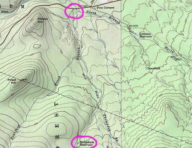
An overview of the area. My goal was to travel about 4-miles as the crow flies, there and back.
Avoid Observation, Be the Observer
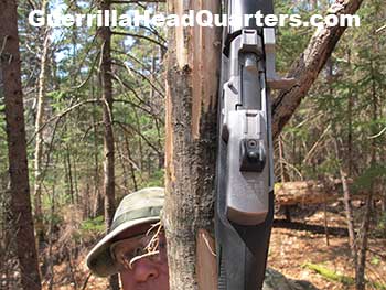
Hiking off-trail and off-road with 35-pounds of gear, plus Ruger Mini-30 rifle (7.62 x 39) with six 20-round magazines plus one in the rifle for a total of 140 rounds.
The real challenge is to get there and back without being seen by the numerous walkers and hikers that frequently travel on the mostly dirt loop road located at the northern foot of the popular Mt. Garfield (elevation 4501-feet).
And, as we shall see, the map is never the territory.
Navigating over unfamiliar mountainous and forested terrain using a topographic map and compass is an exercise in guerrilla movement. For the most part I traveled within hearing distance of the roaring river and used that as my guide, being sure to stay far enough off to the side in order to avoid observation by fishermen etc or someone who happened to be on the opposite bank.
But it is also difficult to avoid bumping up against roads and trails. A big problem is walking right next to frequently traveled area, not being able to detect that fact until suddenly it is too late and someone spots you.
Inevitably unexpected events happen, that must be adapted to and serendipitous chance plays a role that cannot be discounted. It pays to be observant, sometimes the smallest scrap of information or observation can mean the difference between being found and remaining unseen.
Conditions
Waking up to an early morning frost, the first sign of leaves are just starting to show the tiniest bit of green on some of the early species of trees. A few dandelions here and there on front yards, but not many other flowers have yet awakened from the long winter. There has been some talk of ticks coming out of torpor and attaching to local people but I have yet to see any this year.
The surrounding mountains still have plenty of snow, so much so that snowshoes are needed in the higher elevations, especially if you wander off trail where the snow hasn’t been packed by hikers.
There is some danger of being cut off by rising water during the day as brooks and rivers rise due to snow melt and the hot spring sun. This happened recently to a couple hiking a few miles from here, and they were “rescued” by Fish and Game after being reported missing by friends.
Forest conditions are leafless trees, very dry duff on the forest floor that crackles and snaps with every step. This means two very important things:
- Sight distances are much further than usual, though as always even just 50 yards is unusual.
- Walking is very noisy.
Parking my truck just off Route 3, next to the Loop Road gate, I bounded off into the forest beside the branch of the river I would be following upstream. The forest is thick, with numerous blown down trees, interlocking shrubs, etc, making for the usual obstacle course the great Satin himself could never dream up. Such is the life of the off-trail hiker.
It wasn’t long before I came upon a concrete dam that appears to be abandoned. It’s upstream side has been filled in with river rock by the floods that frequent this steep mountain stream. Beside the dam in a small building made of cinder block, beside which is the gate made of wood that can be raised or lowered via some sort of crank. This may or may not be rusted shut, but in any case the dam is now pretty much useless for holding back much water. A mowed field of about 1/4-acre in size that seems to be maintained is located beside the building.
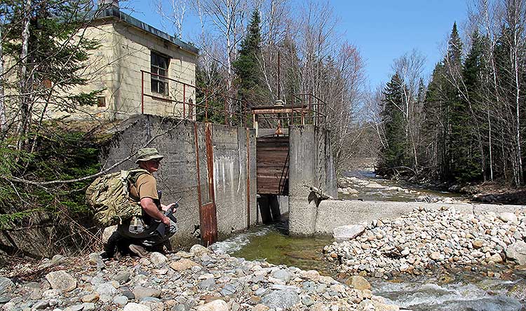
A dam, building, and field not shown on my map. Looking down river you can just see Route 3
I noticed that the dam is currently crossable as the water is being forced to either side. During very high water it would not be.
Interestingly, this dam nor the building or field are located on the Appalachian Mountain Club topographic map I was using. However the building and field (but not the dam) are located on the USGS Topographic Map I have interfaced with Google Maps.
Again, the Map is Not the Territory. When you come upon an unexpected structure, perhaps the area is patrolled or even staked out. Someone could be in the building, perhaps a maintenance crew. Even if you skirt the dam, you will still have to cross the access road and all roads are problematic due to the very fact they are traveled – after all that is the reason for a road being there!
A short way up river from the dam I came upon a huge yellow birch tree that had fallen across the stream. Looking at the map, I could see that the spit of land I was traveling on, wedged between the Loop Road and the river would become progressively narrower the further I went to the point where I would have to cross one or the other. Since I didn’t want to cross the road, which is a very exposed and dangerous thing to do, and I didn’t want to get my feet wet in the icy stream, I chose to cross while the crossing was good.
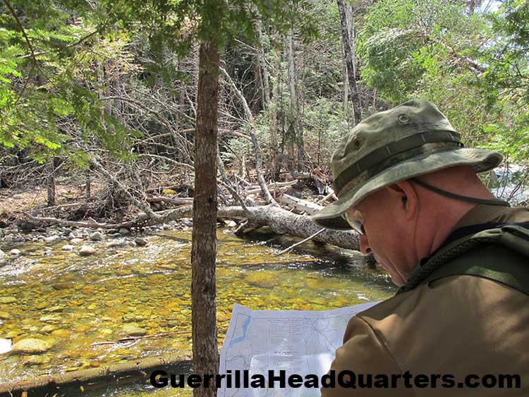
Where a large fallen tree bridges the stream, I read the map in deciding whether to cross or not.
Of course crossing like this has its disadvantages, being exposed for perhaps 30 seconds but with the alternative of crossing the road I took my chances.
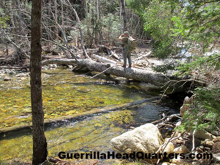
Crossing the river on a fallen tree.
From there I was soon faced with a 75-foot nearly versicle embankment, which I climbed with some difficulty to reach a remarkably flat area at the top. Sounding like a broken record player, the map is not the territory as this steep embankment is not revealed at the scale of topo map.
Continuing on, guided by the sound of the rushing river below me, I made sure not to silhouette myself on the edge of the bank. Eventually I came up a piece of wax paper laying on the forest floor. Relatively fresh, the paper had no dead leaves on it – meaning it may have been deposited after last Fall season.
I smelled it and detected a light perfume scent. Experience has taught me that most people wear scented deodorants. Since I do not (I use plain baking soda) my nose easily detects these scents, which tend to wear off over time.
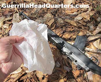
Fresh wax paper. A clue, but a clue to what?
But how did this paper come to rest in the middle of the forest at such a distance from road or trail?
Carefully I scouted a hundred yards or so perpendicularly from my intended route, thinking I may intersect a logging road not shown on the map. If such a road existed, perhaps the paper blew in from there from a loggers or walkers lunch. I also carefully scanned the area for tracks, which would be easy to see (with trained eyes) in the thick, damp, forest soils. However I found nothing except for moose spoor, which lead me to wonder how a fresh piece of wax paper came to be where I had found it.
Moose tracks, moose scat, and bark stripped from striped maple trees, a favorite food for moose.
Contact!
Suddenly, contact.
Without warning I walked upon the edge of a large log landing, several acres in extent. It has been used within the last several years as the trees growing upon it are mostly short field pine. At the very moment I was within just a few trees of the edge of the clearing, directly in front of me, just 250 feet away, were to hikers – and they were looking directly at me.
Alas, not shown on my map were this clearing nor the large new logging road the hikers were standing on. They had come upon the clearing at the same moment I had and the direction of travel on the road was facing directly at me, from which the road veers away toward the river and the Loop Road.
There as basically little I could do as the two men talked and pointed. If I dropped to the ground or scampered off toward concealment the human eye is expert at detecting movement. The sound of snapping and cracking underbrush would also give me away. What I counted on is that I was in a relatively shady spot and they were standing in the open in full sunlight. I had a myriad of trees, twigs, and entangled background behind me as well as a few small sapling trees beside me.
Impromptu Camouflage
Caught unexpectedly, nearly in the open. Two men looking directly at me but maybe not knowing what they were looking at.
Here is what I did:
- Slowly moved so that a 4-inch diameter sapling tree was directly between the men and the center of my body. This served to split my silhouette but even more importantly to hide my white arms and face.
- Turned my body to show them my side instead of full frontal. I attempted to make myself as narrow as possible to their view. The front showing silhouette of a man is to be avoided as it is easily recognizable.
- Put my rifle leaning against the far side of my body to them.
- Brought my chin down into my chest so that my boonie hat covered as much as my face as possible and further reduce my silhouette from looking like that of a standing man.
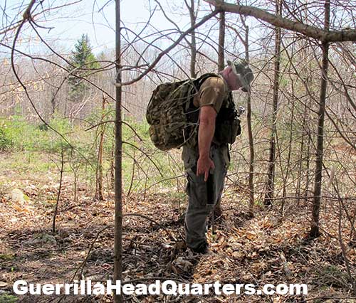
Re-enacting impromptu camouflage. I have turned side to and placed a small tree between myself and two men just 250-feet away.
Heart racing, I could hear them talking though at that distance could not understand what they were saying as they stood there for a full minute looking directly at me across the field.
And then they left. I could see their heads and bodies going in and out between the thick forest as they took the turn of the road and headed steeply downhill on the logging road toward the Loop Road and the river. The wind was coming up from the river directly toward me and sniffed the air – sure enough they cut the drift of air and were likely headed downstream on the main road.
I carefully scouted around the full perimeter of the field but I was very curious about what just happened. Removing my pack, I hung in up in the small tree I had been hiding behind and stowed my web gear, and rifle. With only my camera I paced off the distance between my pack and where the men had been standing – only 250-feet over a clear field. I then took a picture of my pack, which is zoomed in below:
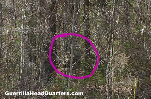
It is very difficult to see my camo pack hanging in the tree – even across an open field. I was standing behind this small sapling as the men looked directly at me.
Pretty incredible actually. I could seem them very clearly but as long as I stood very still and utilized even the sparse concealment I had they would have a very difficult time seeing me.


